basic concepts of surveying
the level
the level A level essentially comprises a telescope rotatable about a vertical axis; it is usued to create a horizontal line of sight so that height differences can be datermined and stakeouts can…
 basic concepts of surveying
Curves
In the geometric design of motorways , railways , pipelines , etc , the design and setting out of curves is an important aspect of the engineer’s work The initial design is usually based on a serie…
 basic concepts of surveying
Sight distances
Driver Eye Height Sight distance is a safety design factor which is intrinsically linked to rate of change of grade , and hence to K - values Consider once again the hump - backed bridge Drivers a…
 basic concepts of surveying
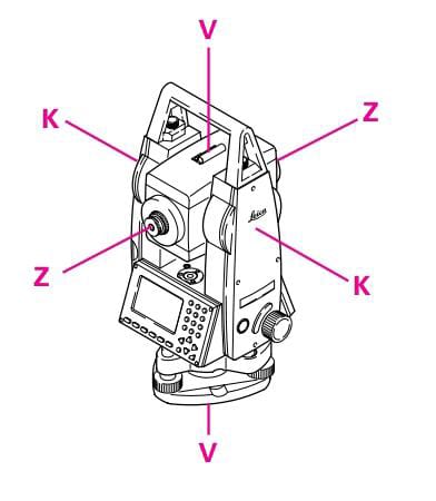
Instrument errors in the total station
ldeally , the total station should meet the following requirements: a) Line of sight ZZ perpen- dicular to tilting axis KK b) Tilting axis KK perpen- dicular to vertical axis VV c) Vertical axis V…
 basic concepts of surveying
Remote heights
1- Set out the total station in the terrain so that it is within viow of surveyed. it is not necessary to pisition the horizontal circle. 2- Determinethe boundary points of the area sequentially dir…
 basic concepts of surveying
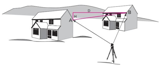
the distances
The program determines the distance and height difference between two points. 1. Set up the total station at any location. 2. Measure the distance to each of the two points A and B. 3. The distanc…
 basic concepts of surveying
Setting up the instrument anywhere
1- Extend the legs of the tripod as far as is required and tighten the screws family. 2- set up the tripod so that the tripod plate is as horizontal as possible and the legs of the tripod are f…
 basic concepts of surveying
Free station surveys
This program calculates the position and height of the instrument station, along with the orientation of the horizontal circle, from measuremnts to at least two points, the coordinates of which …
 basic concepts of surveying
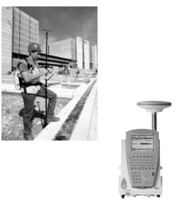
Surveying with GPS
GPS surveys use the signals transmitted by satellites having trajectories such that any point on the Earth's surface can be determined around the clock and independently of weather condition…
 basic concepts of surveying
GALILEO
Galileo is a joint initiative of the European Commission ( EC ) and the European Space Agency ( ESA ) When fully operational the system will have 30 satellites in three planes , placed equally arou…
 basic concepts of surveying
The future for surveyor and engineers
The future for GPS , WAAS and EGNOS and Galileo looks promising The future for GLONASS is harder to assess but could also match expectations In the worst case if only the GPS satellites and all of…
 basic concepts of surveying
Staking out point heights
in an excavation, point B is to be set out at a height ∆H =1.00 metre below street level (point A). 1- set up the level so that the sighting distances to A and B are about the same. 2- set u…
 basic concepts of surveying
Datum Transformations
Datum Transformations Coordinate transformations are quite common in surveing . They range from simple translations between coordinates and setting-out grids on a construction site , to transfo…
 basic concepts of surveying
Basic principle of position fixing
Position fixing in three dimensions may involve the measurement of distance ( or range ) to at least three satellites whose X Y and Z positions is known in order to define the user’s Xp Yp and Zp po…
 basic concepts of surveying
European Geostationary Navigation Overlay Service-EGNOS
EGNOS is the European counterpart of the US WAAS It is a joint project of the European Space Agency ( ESA ) the European Commission ( EC ) and Eurocontrol the European Organization for the Safely o…
basic concepts of surveying
Static positioning
This method is used to give high precision over long baselines such as are used in geodetic control surveys at its simplest one receiver is set up over a station of known X,Y,Z coordinates prefe…
basic concepts of surveying
Resolving the integer ambiguities
The process of resolving the integer ambiguities is called initialization and may be done by sitting up both receivers at each end of a baseline whose coordinates are accurately known In subse…
basic concepts of surveying
Reoccupation
This technique is regarded as a third from of static surveying or as a pseudo kinematic procedure it is based on repeating the survey after a time gap of one or two hours in order to make use of the…
 basic concepts of surveying
setting up the total station over a groun point
1- place the tripod approxi - mately over the ground point. 2- lnspect the tripod from various sides and correct its position so that the tripod plate is roughly horizontal and about the ground po…
 basic concepts of surveying
Measuring distances optically with the level
the reticle carries two stadia lines arranged symmetrically to the crosshair. their spacing is such that the distance can be derived by multiplying the corresponding staff section by 100.(This d…
Popular Posts
-
 حساب مساحة شكل غير منتظم حساب مساحة شكل غير منتظم نتعرف اولا علي ا لاشكال الهندسية غير المنتظمة اما ان تكون علي شكل مضلع كثير الاضل...
 -
 الخط الخارجي للشكل الغاية من بحث رسم الخط الخارجي للشكل هي عملية تنظيم وترتيب مسافات وزوايا وابعاد ونقط الاشكال والتفاصيل علي سطح الارض ...
 -
 مفهوم واستخدامات البوصلة المنشورية عرف البوصلة علي قياس انحرافات اتجاهات الاهداف علي سطح الارض عن اتجاه الشمال المغناطيسي حيث انه اذا و...
 -
 الترافرس المساحي انشاء المضلعات الترافرس Traverse يلجأ عمليات المسح التفصيلي ورسم الخرائط كبيرة المقياس الي انشاء مضلعات تصل بين نقاط ...