Sight distances
Driver Eye Height Sight distance is a safety design factor which is intrinsically linked to rate of change of grade , and hence to K - values Consider once again the hump - backed bridge Drivers a…
Instrument errors in the total station
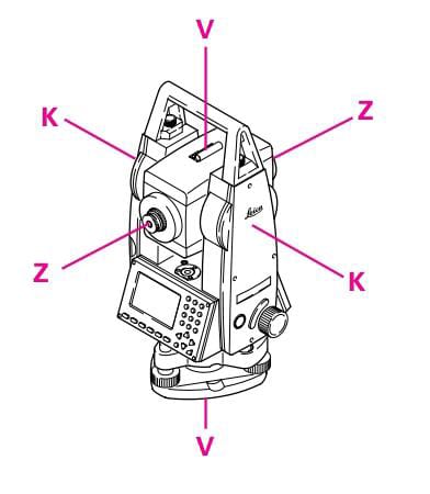
ldeally , the total station should meet the following requirements: a) Line of sight ZZ perpen- dicular to tilting axis KK b) Tilting axis KK perpen- dicular to vertical axis VV c) Vertical axis V…
Remote heights
1- Set out the total station in the terrain so that it is within viow of surveyed. it is not necessary to pisition the horizontal circle. 2- Determinethe boundary points of the area sequentially dir…
the distances
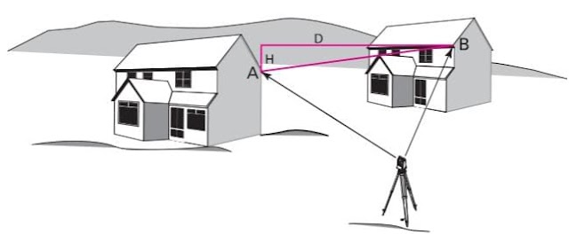
The program determines the distance and height difference between two points. 1. Set up the total station at any location. 2. Measure the distance to each of the two points A and B. 3. The distanc…
Setting up the instrument anywhere
1- Extend the legs of the tripod as far as is required and tighten the screws family. 2- set up the tripod so that the tripod plate is as horizontal as possible and the legs of the tripod are f…
Gps Reference stations
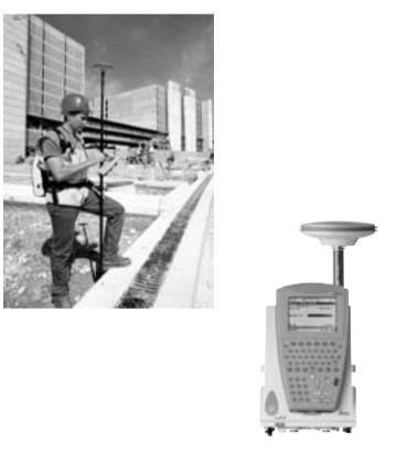
Also known as a conti- nuously Operating Refe- rence Station (CORS), this is typically a dual-frequency GPS receiver located at known coordinates, supplied with permanent power and connected to …
Free station surveys
This program calculates the position and height of the instrument station, along with the orientation of the horizontal circle, from measuremnts to at least two points, the coordinates of which …
Surveying with GPS
GPS surveys use the signals transmitted by satellites having trajectories such that any point on the Earth's surface can be determined around the clock and independently of weather condition…
Deformation monitoring
Navigation Gps Use GPS is now used in all aspects of navigation GPS voice navigation systems are standard with many models of car Simply typing the required destination into the unit results in a g…
GALILEO
Galileo is a joint initiative of the European Commission ( EC ) and the European Space Agency ( ESA ) When fully operational the system will have 30 satellites in three planes , placed equally arou…
Machine guidance and control
Machine Guidance Earth moving is required to shape the ground prior to construction taking place In this context machine guidance is concerned with guiding the operator to move the blade or dozer.…
توقيع المعالم الافقية والراسية
الطرق المساحية في اعمال توقيع المعالم الافقية تتطلب نقاطا معلومة الاحداثي و محددة الموقع في الطبيعة لبدء العمل منها و عادة تحدد نقاط لهذا الغرض سواء في الخرائط المساحية - او الصور الجوية - او الرسو…
locating position
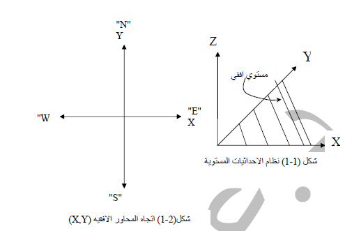
topographic survey establishing control network and their subsequent computation leads t an implied rectangle coordi-nate system over the area surveyed , the minor control point in particular ca…
The future for surveyor and engineers
The future for GPS , WAAS and EGNOS and Galileo looks promising The future for GLONASS is harder to assess but could also match expectations In the worst case if only the GPS satellites and all of…
المنحنيات الراسية Parabola vertical curve
عندما يتقاطع المحوران المستقيمان عند زاوية تقاطع في مستوى راسي فان المنحنى الذي يصل المحورين المستقيمين يسمى منحنى راسي و تستخدم لتلافي تلاقي خطين في المستوى الراسي و لاعطاء معدل تغير منتظم في ال…
المبادئ الاساسية للمساحة Basic principles of surveying
1- العمل من الاكبر الى الجزء و ذلك لتقليل تاثير الاخطاء في اعمال المساحة الى الحد المسموح بها في مسح التفاصيل. 2- الاقتصاد في الدقة Economy of accuracy حيث انه كلما كانت الدقة اعلى كلما كانت كل…
اخذ القياسات
لو نظرنا الى الشكل ( 1-3 ) هناك عدة انواع من القياسات بالامكان اجراءها لغرض تحديد الاحداثيات الافقية للنقطة C : ا - قياس الزاويتين الافقيتين الى اليمين CAB , ABC ب - احدى المسافتين الافقيتين A…
Staking out point heights
in an excavation, point B is to be set out at a height ∆H =1.00 metre below street level (point A). 1- set up the level so that the sighting distances to A and B are about the same. 2- set u…
Datum Transformations
Datum Transformations Coordinate transformations are quite common in surveing . They range from simple translations between coordinates and setting-out grids on a construction site , to transfo…
Comments
Blog Archive
Popular Posts
-
حساب مساحة شكل غير منتظم حساب مساحة شكل غير منتظم نتعرف اولا علي ا لاشكال الهندسية غير المنتظمة اما ان تكون علي شكل مضلع كثير الاضل...
-
الخط الخارجي للشكل الغاية من بحث رسم الخط الخارجي للشكل هي عملية تنظيم وترتيب مسافات وزوايا وابعاد ونقط الاشكال والتفاصيل علي سطح الارض ...
-
مفهوم واستخدامات البوصلة المنشورية عرف البوصلة علي قياس انحرافات اتجاهات الاهداف علي سطح الارض عن اتجاه الشمال المغناطيسي حيث انه اذا و...
-
الترافرس المساحي انشاء المضلعات الترافرس Traverse يلجأ عمليات المسح التفصيلي ورسم الخرائط كبيرة المقياس الي انشاء مضلعات تصل بين نقاط ...
Sections-BTLabels
- اجهزة المساحة
- أستخدام أحدث تقنيات الرصد علي الأقمار الصناعية
- استلام اعمال التنفيذ
- اعمال الميزانيات
- الارض
- التوقيع المساحي
- الخرائط الطبوغرافية
- الرسم المساحي
- الرفع الطبوغرافي
- المناقصات
- الهندسة الطرق
- الهندسة المساحة
- انشاءات
- برامج هندسية
- تعريفات ومصطلحات
- تعلم برامج محرر النصوص
- حساب المثلثات
- حساب كميات التشطيبات للمشروعات
- حساب وقياسات
- خطوط الكنتور
- علم المساحة
- علم المساحة والخرائط
- فيديو
- مقياس الرسم
- منتجات الكترونية
- مواسير الصحي
- نظم المعلومات الجغرافية
- نيجيريا
- وظائف
- Auto Cad
- basic concepts of surveying
- GIS
- GPS
- sokkia
- surveying
- theodolite
إتصل بنا
المتابعون
Popular Posts

مفهوم واستخدامات البوصلة المنشورية


