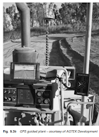
Navigation Gps Use
GPS is now used in all aspects of navigation GPS voice navigation systems are standard with many models of car Simply typing the required destination into the unit results in a graphical display of the route , along with voiced directions
Similar systems are used by private boats as digital charts and by aeroplanes, whilst handheld receivers are now standard equipment for many walkers and cyclists
GPS has many applications for sports monitoring and provides the spatial and time element of the data for sports performance analysis
GPS enabled wristwatches and mobile phones have been available for several years now
GPS is used in fleet management for determining the vehicles positions and status so that they can be transmitted to a central control thereby permitting better management of the assets
At the individual vehicle level the driver can use GPS as an aid to destination and route location
GPS is used by surveying ships for major offishore hydrographic surveys
Ocean going liners use it for navigation purposes , whilst most harbours have a DGPS system to enable precise docking
Even recreational craft rely on it almost to the exclusion of traditional methods of navigation and pilotage
At the present time , aircraft lading and navigation are controlled by a variety of disparate systems
GPS is well used and may eventually provide a single system for all aircraft operations
The uses to which GPS can be put are limited only by the imagination of the user
They can range from the complexities of measuring tectonic movement to the simplicity of spreading fertilizer in precision farming and include many areas of scientific study , such as meteorology , oceanography , and geophysics
As satellite systems continue to develop the applications will continue to grow
The advantage of using GPS is that it enables near real - time monitoring for deformation if data recorded and processed online
There are a number of such projects currently operational and are described at their respective websites
Examples include monitoring by Nottingham University of the number Bridge and a bridge in Nottingham for movement
natural disasters such as landslides volcanoes and earthquakes
Since information about actual vibration is of use to engineers the output of other technologies such as accelerometers may be incorporated with that of GPS through mathematical techniques like Kalman filtering
Kalman filtering is a predictor corrector process that enables solutions of position and velocity of greater precision than those obtainable with either GPS or the accelrometers alone
The GPS based online Control and System ( GOCA ) developed at Fachochschule Karlsruhe University of Applied Sciences , Germany , can be used for the online monitoring of movements associated with , and preceding , natural disasters such as landslides , volcanoes and earthquakes
The system may be entirely GPS based or use total stations as well as in Figure 9.29
The system can also be used to monitor safety critical movement of buildings or dams
The online modelling of a classical deformation network loads to the computation and visualization of time series data of individual receivers
With filtering and analysis of the data it is possible to detect movements that are significant , but much smaller than the precision of individual GPS measurements
These movements may trigger an automatic alarm and give warning of an impending disaster


0 تعليقات
اذا كنت خارج البلاد ومحتاج معلومة مهمة ومش لاقيها ! ممكن دلوقتي تكتب نوع المعلومة الي انت محتاجها وراح نجاوبك بيها علي طول من خلال اضافتها للموقع او من خلال الرد عليك من خلال بريدك الالكتروني او الاتصال بك مباشرة
(أطلب الشرح الي انت محتاجة ولا تتردد)
فريق منارة العلوم يساعدك علي مدار 24 ساعة