
 basic concepts of surveying
computer systems to be economically viable
to be economically viable , practically all major engineering /surveying organization use an automated plotting system very often the total station and logger are purchased along with the comput…
 basic concepts of surveying
plotting detail in the past , detail would have been plotted on paper
in the past , detail would have been plotted on paper or a more stable medium such as plastic film . however , today all practical . plotting , is computer based there is an abundance of compute…
 basic concepts of surveying
locatiog position establishing control networks and their subsequent
establishing control networks and their subsequent computation leads to an implied rectangular coordi- nate system over the area surveyed. the minor control point in particular can now be used t…
 حساب المثلثات
حساب المساحات
حساب المساحات حساب المسافة الافقية تتوقف طريقة حساب المساحة علي طريقة الرصد والمعلومات المرصودة وفيما يلي نوجز بعض الطرق المستخدمة في حساب المساحة الأفقية حساب المسافة الأفقية بمعلومية المسافة المائل…
 نظم المعلومات الجغرافية
شبكة الاحداثيات
شبكة الاحداثيات ما هو نظام الاحداثيات wgs84 هناك نظم متعددة للأحداثيات ولكل دولة نظام أحداثي خاص بها حتي أن نظام أل GPS له نظام أحداثيات خاصه به يسمي world geodetic system 84 l WGS 84 وعندما حصل…
 حساب المثلثات
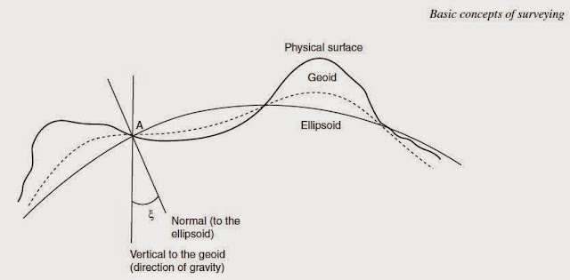
basic measurments
surveying is concerned with the fixing of position whether it be control point or point of topographic detail and ,as such requires some form of refernce system. the physical surface of the…

safeguarding
safeguarding since survey can be an expensive process sensible precaution should be taken to ensure that the work is not compromised, safeguarding is concerned with the protection of work . obs…
 basic concepts of surveying
the independent check
the independent check the independent check is a teachnique of assurance . it is a means of guarding against a blunder or gross error and the principle must be applied at all stages of a surve…
 basic concepts of surveying
economy of accuracy
economy of accuracy surveys only ever undertaken for aspecific purpose and so should be as accurate they need to be , but not more accurate.in spite of modern equipment , automated systems , an…
 basic concepts of surveying
control
control acontrol network is the framework of survey stations whose coordinats have been precisely determined and are often considered definitive. the station are reference monuments, t…
 basic concepts of surveying
principles
principles every profession must be founded upon sound practice and in this engineering surveying is no different . practice in turn must be based upon proven principles . this section is…
 basic concepts of surveying
definition
definition surveying may be defined as the science of determining the position in three dimensions of natural and man made features on or beneath the surface of the earth .…
 الهندسة المساحة
وحدات القياس بالانجليزي
وحدات القياس بالانجليزي نعني في المساحة بوحدات القياس تلك التي نعبر بواسطتها عن مقادير كل من الأطوال والزوايا والأتجاهات والمساحات والحجوم . بالنسبة للأطوال والمساحات والحجوم نستعمل…
 حساب وقياسات
قياس المساحات الطريقة الميكانيكية
قياس المساحات يمكن حساب وتقدير المساحات أما من الخرائط أو من الطبيعة مع الأخذ بعين الاعتبار أن المساحات التي تحسب عن طريق المسقط الأفقي وليست عن طريق المساحات الحقيقية أي أنه دائما نأ…
 تعريفات ومصطلحات
تعريف خطوط الكنتور
تعريف خطوط الكنتور هي الشكل الفعلي لسطح الأرض من أرتفاعات وأنخفاضات يعبر عنها علي ال خرائط بخطوط تسمي (contours) ال خطوط الكنتور ية وعادة ماترسم خرائط كاملة لهذة الخطوط تسمي بال…
 تعريفات ومصطلحات
تعريف المساحة المستوية
تعريف المساحة المستوية plane surveying هي علم تحديد مواقع علي سطح الأرض أو قريبا منها لبيان الحدود والمعالم الطبيعية والغير طبيعية لآجزاء من سطح الأرض ثم تمثيل هذه المعالم في رسومات …
 الرسم المساحي
رموز الخريطة وأنواعها
رموز الخريطة وأنواعها عندما يراد رسم خريطة لمنطقة ما يجب أولا أختيار ال مقياس المناسب لها ثم يرسم هيكل المنطقة مع بيان مواضع النقط ويرسم دوائر عليها وتوقع علي الخريطة الأبعاد وال…
تعريفات ومصطلحات
تعريف المساحة الحقلية
تعريف المساحة الحقلية field surveying المساحة الحقلية أو المساحة الميدانية هي أعمال القياس التي تتم علي سطح الأرض وتأخذ فيها القياسات من السطح مباشرة بأستعمال أجهزة قد تكون بسيطة أو متق…
 تعريفات ومصطلحات
تعريف المساحة
تعريف المساحة المساحة هي فن قياس المسافات الأفقية والرأسية بين النقط أو قياس الزوايا الأفقية والرأسية بين الخطوط والنقط وتعيين اتجاهات الخطوط وتوقيع نقط من واقع قياسات زاوية وطولية سبق تعيينها . و…
 الهندسة المساحة
وحدات قياس المسافة
وحدات قياس المسافة يعتبر قياس المسافات بين النقاط المختلفة علي سطح الأرض أحد العمليات الأساسية في حقل المساحة . فعلي سبيل المثال لتعيين موقع نقطة ما يستعان بقياس المسافات أو الزوا…
Popular Posts
-
 حساب مساحة شكل غير منتظم حساب مساحة شكل غير منتظم نتعرف اولا علي ا لاشكال الهندسية غير المنتظمة اما ان تكون علي شكل مضلع كثير الاضل...
 -
 وحدات قياس المسافات وحدة قياس الطول و المسافات وحدة قياس الطول النظام المتري هو النظام المستخدم في عمليات القياس وفيما يلي بعض العلاقات...
 -
 مقياس الرسم مقياس الرسم احدي طرق لقياسات المسافات ويعرف بانه النسبة بين طول اي بعد علي الخريطة والطول المناظر له في الطبيعة ، مثلا ١ /١٠...
 -
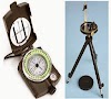
 انواع الاجهزة المساحية اجهزة مساحة هناك احدث انواع الاجهزة المساحية بكافة اشكالها والوانها انواع الاجهزة المساحية المختلفة اجهزة مساحة الكتر...